
The administration labels climate change a hoax. Those outside the bubble of the East Coast, be they Democrats or Republicans, know better. As Ben Franklin said: “When the well is dry, we learn the worth of water.” As a person who has only practiced western water law for over four decades, I have a blunter saying: Those that have plenty of water have no concept of the resource; you only understand water if you have none.
The seven basin states that rely on the Colorado River all know the value of water and the dramatic impact that climate change has had and continues to have on the basin. In the past thirty years, the Colorado River’s flow has declined by 20%. That is projected to decline to 30% by 2050. Ambient atmospheric temperatures in the Colorado River basin have increased by 2.3 degrees in that same period and are projected to be +4 degrees by 2050.
Tainting science with politics is meaningless and further complicates the tasks of water managers. Just because you hide or deny a problem, the problem does not go away. Climate models all show the same results and trends. No model prepared by reputable scientists shows anything different. The models, to name just a few were generated by the US Bureau of Reclamation, the National Oceanic and Atmospheric Administration, Colorado State University, and National Research Council. They all reveal the same picture. We can’t deny ourselves out of the mess, we have to recognize and solve challenges, the best we can.
A brief summary of how we got here: In the 1880s, a young country sought to expand west and defend what it had. Los Angeles and San Diego were seen as strategic defensive necessities. The railroads and mining were drivers of western settlement. The Homestead Act of 1862 granted 160 acres to anyone willing to farm the land. The 1902 Reclamation Act provided cheap tax-payer subsidized irrigation water to farm while massive federal dams and canals were funded by the treasury to deliver that water.
The result was that the arid west was settled. What came next in this tight waterscape was conflict over limited water resources between the states. California and Arizona were growing at a pace faster than the upper basin states of Colorado, New Mexico, Utah, and Wyoming. The west’s water laws of the prior appropriation doctrine, mirror the miner’s credo of staking claims proclaims, “First in time, First in right.” Fearing that the lower basis states might usurp the future of other states, the seven states and the federal government convened negotiations to allocate the flow of the Colorado River.
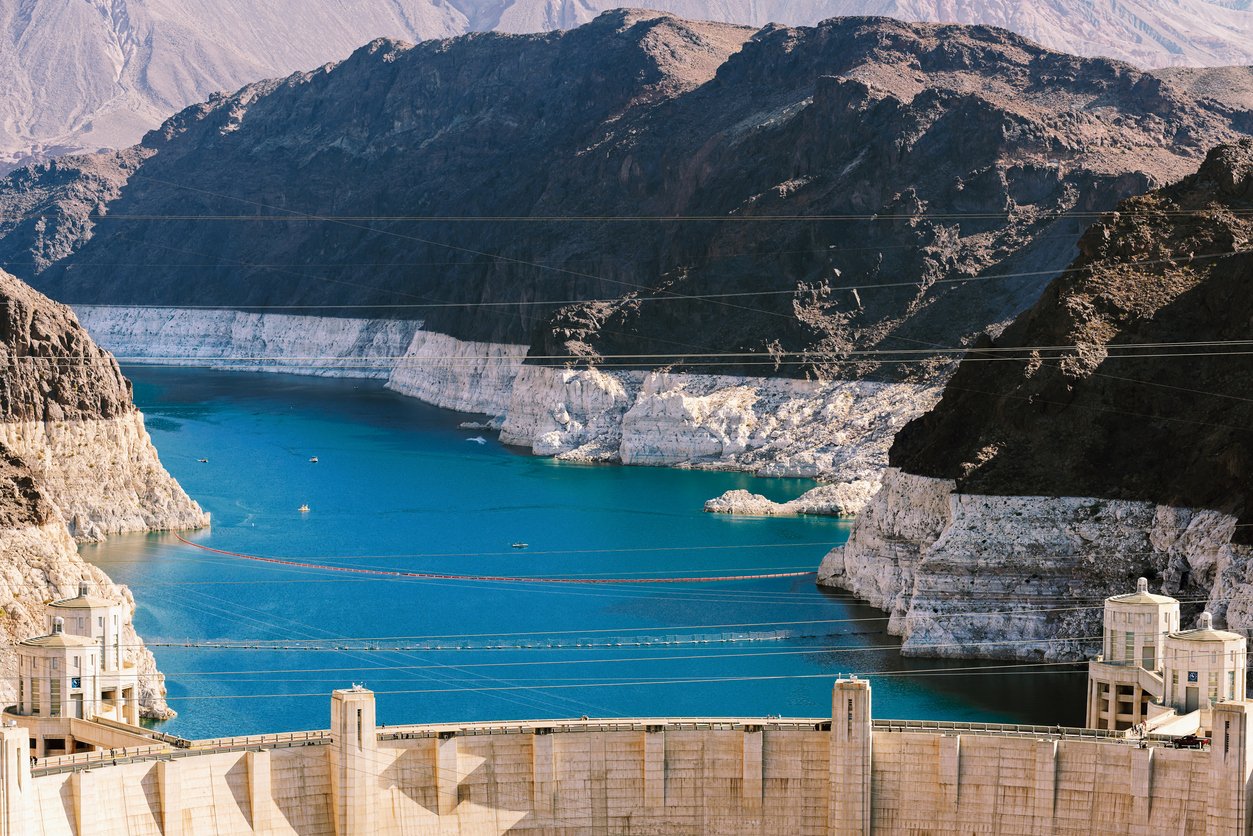
While an article on this subject could fill libraries, suffice to say that the river was divided in half. Above Lee’s Ferry, Arizona (just below the dam at Lake Powell), the upper basin states were allocated 7.5 million acre feet on a ten year running average and the lower basin states of Arizona, California, and Nevada were allocated the other half. Off the top, 1.5 million acre feet was to go to Mexico by treaty. The engineering assumptions, based on a twenty year average, were that the native flow of the river was between 16.4 and 18 million acre feet.
Turns out that the period of study used fell within the one hundred years between 1890 and 1990 when paleoclimatic records show to be the wettest hundred year period since A.D.800 and that was the wettest in the previous 10,000 years. During the period after the compact was signed until the impacts of climate change began in the late 1980s, the river flowed around 15-16 million acre feet. With the advent of climate change, the flow now dips below 13 million acre feet/year. All models show that by 2050, this amount could be reduced by as much as an additional 10%.
The states have attempted to address this conflict. A deadline imposed by the federal government that largely manages the lower basin has come and gone. The legal conflict largely centers around gravity and language.
First, the language: To the four Upper Basin states and the three Lower Basin states, the compact allocated “the exclusive beneficial use of 7,500,000 acre-feet of water per annum…” (an additional 1.0 million acre-feet was available to the Lower Basin if surplus existed, so we can forget that). The burden of meeting the Mexico treaty obligation is shared between the Upper Basin and Lower Basin. The key factors are there is no expressed delivery obligation at Lee’s Ferry and evaporation is not mentioned. Lake Powell, located in the Upper Basin, is estimated to evaporate 300,000-500,000 acre-feet per year. Lake Mead, located in the Lower Basin, is estimated to evaporate as much as 1.9 million acre-feet annually. Additional evaporation occurs from the headwaters to Mexico.
Then comes gravity: The old saying is “I’d rather be upstream with a shovel, than downstream with a right.” The Upper Basin states say, “Hey, we haven’t used our 7.5 maf. The Lower Basin is evaporation and using more than 7.5 maf.” The Lower Basin states assert everyone should share in evaporation and the natural deficit.
The feds say they will “impose” a solution. That has doubtful legal authority. The compact is both a contract between the parties and an Act of Congress. The US Constitution, Art. 1, Sec. 10, provides that states may contract between themselves only with the consent of Congress, so when the contract between the states was signed, Congress’ approval made the contract also an Act of Congress. As we all know, to amend a contract, every contract party must agree. Therein lies the fallacy of the administration’s threat to “impose” a solution.
Some in the Lower Basin have threatened litigation based on the legal concept known as force majeure. Force majeure is a legal concept that excuses contract performance due to an event that cannot be foreseen or controlled (such as acts of God) that prevent performance. The argument is that climate change and the low flow of the river could not be foreseen in 1922 and cannot be controlled. That argument solves part of the definition but arguably not the second half: “that prevent performance.”
Nonetheless, sharing the hardship of climate change on some basis is reasonable and undoubtedly will be a part of any solution. But before we end, some perspective is in order: The Imperial Irrigation District, located in California’s Coachella Valley desert, has an allotment of 3.1 million acre-feet, more than Arizona, Utah, Nevada, and Wyoming…nearly as much as Colorado alone. The District’s 500,000 acres farms lettuces and vegetables supply the nation’s kitchens.
In the late 1880s and early 1900s the Federal government encouraged western expansion with cheap water to farm the great American desert. Like my earlier articles asking the question of whether datacenters should be located in water short areas, it may be time for a similar discussion of agribusiness as well.
In the meantime, the problem of climate change’s impact on the Colorado River is certainly not a hoax. The River supplies over 40 million people and over 2.5 million acres of agriculture. Denver, Phoenix, Tucson, Las Vegas, Los Angeles, San Diego, and places in between are reliant. We cannot ignore that reality or science needed to solve the challenges.